
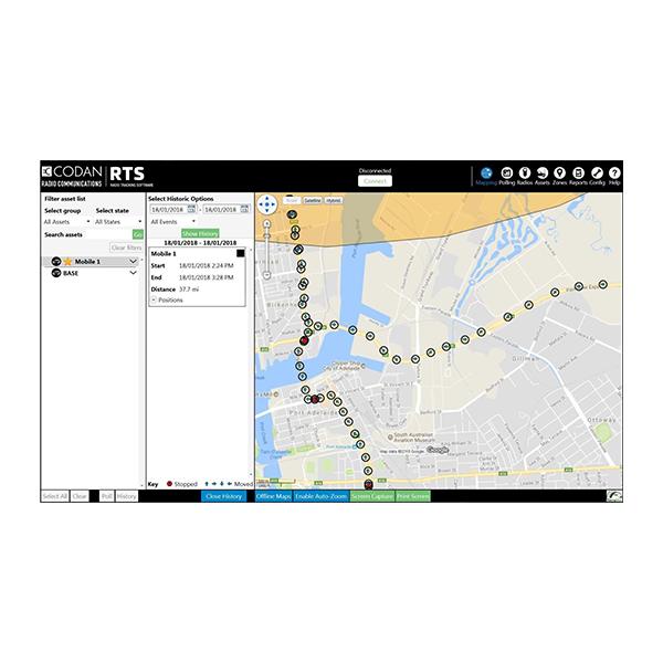
The RTS is HF asset tracking software that locates and manages up to 100 mobile assets over Codan HF radio and GPS, with no air-time costs and street-level world map coverage for GPS-denied operations.
When cellular and satellite tracking stops, RTS keeps teams connected. Combining Codan HF radio and GPS technology, it locates, tracks, and manages up to 100 remote assets with no ongoing air-time costs. Automatic or manual position acquisition is supported via Selcall, 2G, or 3G ALE linking, giving commanders a practical, economical view of assets where commercial tracking cannot reach.
RTS integrates directly with Codan HF radio linking protocols, making position acquisition seamless for operators. Depending on the radio model, connection is supported via USB, Ethernet, Wi-Fi, or serial. Manual and scheduled polling, asset grouping, route planning, basic telemetry, breadcrumb trails, logging, and journey statistics turn raw position reports into a clear operational record. Offline OpenStreetMap world mapping is included, with online map resources available when connectivity returns.
RTS helps maintain situational awareness when infrastructure is unavailable and GPS reliability is compromised. Geo-fencing alerts operators when stations enter restricted areas, leave safety corridors, or approach waypoints. Base-to-mobile and mobile-to-mobile operation are supported, while the included 150 GB street-level world map keeps teams operational offline. With modest system requirements, RTS is built for remote use where other tracking systems go dark.
Automatic or manual position acquisition of up to 100 mobile assets using Selcall, 2G, or 3G ALE linking over HF.
Display a station as individual points or a breadcrumb trace of the route travelled, with user-selectable icons.
Alarm zones, corridor safety zones, and waypoint proximity warnings for maximum situational awareness.
Street-level OpenStreetMap world coverage included offline, with online map resources when internet is available.
An economical alternative to subscription tracking, with no ongoing air-time costs over Codan HF radio.
Connects to Codan HF radios via USB, Ethernet, Wi-Fi, and serial depending on the specific model.
Recovers historical position data, prints route maps, and exports journey statistics filtered by time and geo-fence events.
| Function | HF asset tracking software to locate, track, and manage remote assets over Codan HF radio and GPS |
|---|---|
| Capacity | Up to 100 mobile assets, automatic or manual position acquisition |
| Linking protocols | Selcall, 2G ALE, 3G ALE for GPS data transfer between HF stations |
| Tracking modes | Spot or trace tracking; individual points or breadcrumb trace; asset grouping; route planning |
| Geo-fencing | Alarm zones, corridor safety zones, waypoint proximity warnings; basic telemetry |
| Mapping | Street-level OpenStreetMap world map included; online maps when internet available |
| Logging | Recovery and export of historical position data; route map printing; journey statistics export |
| Radio interfaces | USB, Ethernet, Wi-Fi, and serial depending on model; supports Envoy, Sentry, 2110 Patrol, NGT |
| Processor | Intel Core i3 minimum, 32 bit |
|---|---|
| Memory | 4 GB RAM |
| Storage | 170 GB free hard disk space (includes 150 GB for world street-level map data) |
| Operating system | Windows 7 SP1, 8.1, and 10 (32 bit or 64 bit) |
| Ports | 2 x USB (security dongle and transceiver control); 1 x serial port (NGT only) |
| Screen resolution | 1024 x 768; full HD 1680 x 1050 recommended |
RTS gives operators a complete picture of their remote assets where subscription tracking cannot reach. Combining Codan HF radio and GPS, the software tracks up to 100 mobile assets over Selcall, 2G, and 3G ALE with no air-time costs, plotting positions on an offline street-level world map. Geo-fencing, route logging, and export turn position reports into an operational record, even in GPS-denied conditions. Designed and manufactured by DTC, a Codan Company, RTS delivers dependable HF asset tracking for military and commercial teams in the most remote environments.